Cyclone Alfred latest: Rare Category 2 storm nears Australian coast as millions face ‘worst-case scenario’
Queensland premier warns residents to prepare now for 'extremely rare event'

For free real time breaking news alerts sent straight to your inbox sign up to our breaking news emails
Sign up to our free breaking news emails
Sign up to our free breaking news emails
People on the projected path of Cyclone Alfred have been asked to "act now" and leave before the situation gets worse as an “extremely rare” Category 2 storm barrels towards Australia’s southeastern coast.
“There is a chance this cyclone will cross in the middle of the night with a high tide. That is not the time to be making your evacuation plan, now is the time,” Queensland premier David Crisafulli warned.
Brisbane is shutting down trains, buses and ferry services from Wednesday and several matches and events have been cancelled in Queensland and New South Wales (NSW).
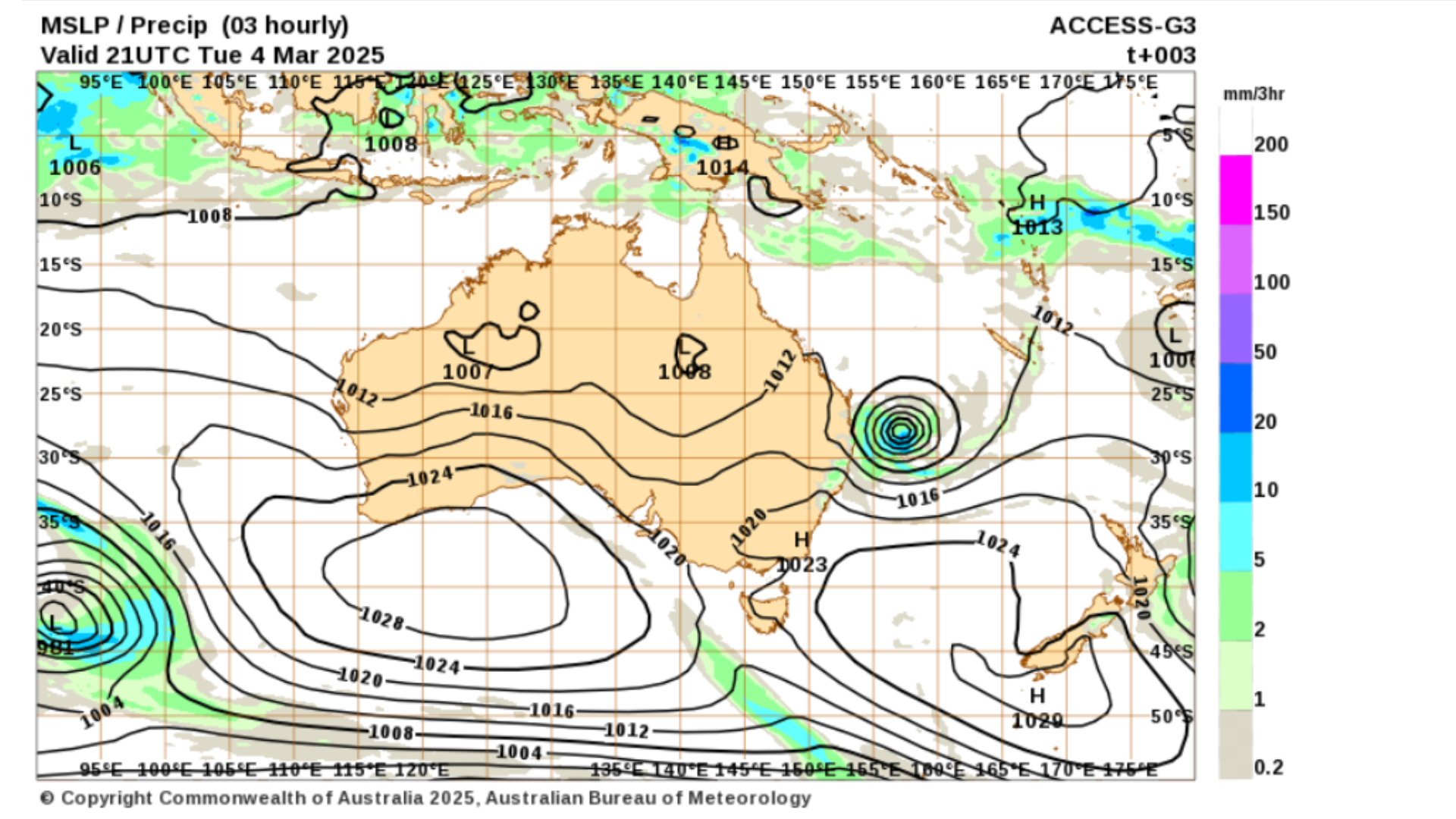
Alfred is now about 325km east of Brisbane, according to the Bureau of Meteorology (BoM). It is moving towards the southeast Queensland coast at 16kmph.
There’s a concern that Alfred could slow down to 11kmph, which would be the “worst case scenario”, Higgins Storm Chasing’s Thomas Hinterdorfer told The Courier-Mail.
The storm is expected to make landfall on Thursday or Friday north of Brisbane, bringing more than half a metre of rain, flooding and destructive winds.
Alfred is the first cyclone to directly impact Brisbane since Nancy in 1990.


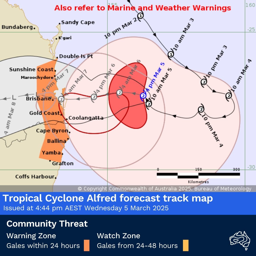
Cyclone Alfred latest map, forecast and warnings
Tropical Cyclone Alfred is moving closer to the southeast Queensland and northern NSW coast, with damaging winds, storm surges, and life-threatening flash flooding expected to worsen overnight into Thursday.
Alfred is now just 325km east of Brisbane and 305km from the Gold Coast, according to the latest (5pm local time) update from the Bureau of Meteorology (BoM).
The area covered by the Cyclone Alfred warning zone stretches approximately 450-500 km along the east coast of Australia, from Double Island Point in Queensland to Ballina in New South Wales.
Damaging winds of 120kmph are already hitting Coolangatta and Ballina while gusts up to 155kmph could hit coastal areas as far south as Cape Byron from Thursday afternoon.
Dangerous storm tides could cause flooding in low-lying coastal areas if landfall coincides with high tide early Friday, the bureau said.
Heavy to locally intense rainfall is expected from late Thursday into Friday, increasing the risk of flash flooding.
Alfred is forecast to make landfall early Friday between Maroochydore and Coolangatta as a Category 2 cyclone.
Airport closures and flight cancellations due to Cyclone Alfred
Airports are shutting down and flights are being cancelled across southeast Queensland and northern New South Wales as Tropical Cyclone Alfred nears the coast.
Gold Coast Airport: The airport will close from 4pm today until further notice. No access will be allowed to the terminal, and people seeking shelter are being directed to the Burleigh Waters Community Centre evacuation centre.
Ballina Byron Gateway Airport: All flights cancelled for Wednesday and Thursday. A total of 22 flights were scheduled to arrive or depart.
Coffs Harbour Airport: Flights suspended from midnight Wednesday until at least midday Thursday.
Lord Howe Island: All Qantas flights cancelled on Wednesday.
Brisbane & Sunshine Coast Airports: Currently operating, but airlines warn further cancellations are possible.
“We have proactively cancelled a number of flights today from southeast Queensland and northern New South Wales," a Qantas Group spokesperson said.
“The situation remains fluid and flight cancellations and delays will evolve over the coming days.”
Earlier, airlines including Qantas, Virgin, Jetstar announced frexible fee-free date change options.
Qantas & Virgin: Customers who booked before 3 March can change their flight within 14 days or cancel for a travel credit.
Jetstar: Free date change 7 days before or 14 days after the original travel date, or a voucher for the full value of untravelled flights.
Map: Heavy rainfall forecast from Cyclone Alfred
Cyclone Alfred is expected to bring torrential rain, with some areas receiving up to 600mm over the next few days, according to forecast from Bureau of Meteorology (BoM).
The heaviest rainfall will likely occur south of landfall, affecting Brisbane, the Gold Coast, the Sunshine Coast, and northern New South Wales.
Expected rainfall totals by region:
Sunshine Coast to Gold Coast: 400-600mm, possibly higher in some areas
Brisbane and Moreton Bay region: 300-500mm
Northern NSW (Tweed, Byron, Lismore, Grafton): 250-400mm, with isolated higher totals possible in river catchments
Coastal areas from Fraser Island to Port Macquarie: 200-350mm
The most intense rainfall is forecasted to hit Thursday night into Friday, with rainfall rates exceeding 200mm in just three hours in some areas.
The latest rainfall map from the bureau shows a widespread area of extreme rainfall, particularly south of the cyclone's landfall, with northern NSW and southeast Queensland at highest risk.
The purple and pink areas on the map indicate the most intense rainfall zones, where flash flooding and major river flooding are highly likely.
The Bureau of Meteorology has also issued its first flood warnings for NSW’s Northern Rivers, with major flooding possible along the Bellinger River at Thora and Bellingen from Friday (See post below).
First flood warning issued for NSW as Cyclone Alfred nears
The Bureau of Meteorology (BoM) has issued its first flood warnings for NSW’s Northern Rivers, as Cyclone Alfred brings heavy rainfall to the region.
Major flooding is possible along the Bellinger River at Thora from Friday afternoon, with water levels expected to rise to 5.8 metres, BoM said.
In Bellingen, the river could surge to 8.2 metres on Saturday, prompting further warnings of major flooding.
Minor flood warnings have also been issued for Repton and the Kalang River at Urunga from Friday afternoon.
“The timing and location of the heaviest falls will depend on the track of the cyclone,” BoM said, adding that the situation is being closely monitored with more warnings to come.
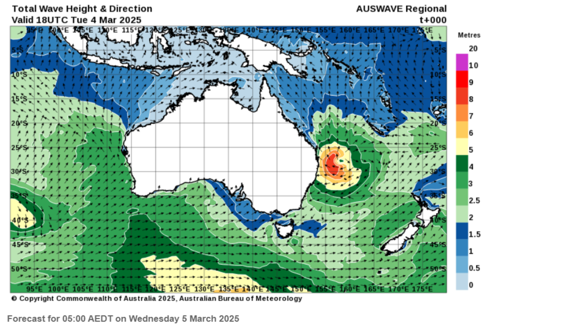
Cyclone Alfred already generating 8-metre waves near epicentre
Massive waves are already building offshore as Cyclone Alfred moves closer, with wave heights exceeding 8–10 meters near the storm’s centre, forecast maps from Bureau of Meteorology (BoM), show.
As the cyclone moves closer, coastal areas in southeast Queensland and northern NSW could see dangerous storm surges, beach erosion, and life-threatening surf conditions over the next 48 hours.
Authorities are warning people to stay away from the water, as conditions will rapidly deteriorate. Flooded roads, coastal inundation, and strong rip currents are expected as the system nears landfall late Thursday or early Friday.
“Tropical Cyclone Alfred triggered the largest waves that we have recorded – over seven metres on Monday morning – since we first started measuring waves at One Tree Island in November 2022," Professor Ana Vila-Concejo from the University of Sydney, said.
“What makes it uniquely hazardous," she said, is that "the coast is already eroded from the run of NE and E swells and very high tides from the last couple of days.”
Buses and trains in Brisbane to shut down tonight ahead of Cyclone Alfred
Brisbane City Council has announced all bus services will be suspended from tonight’s last service until further notice as Tropical Cyclone Alfred approaches.
Buses: Last services tonight, then fully suspended
Trains: Suspended from Thursday until further notice
CityCat & Ferries: Already suspended
Authorities say services will only resume when it is safe.
Full address: Queensland premier David David Crisafulli on Cyclone Alfred
Cyclone Alfred 'extremely rare event,' Queensland premier warns
Queensland premier David Crisafulli has warned residents to "prepare now" as he called Cyclone Alfred an "extremely rare event".
Authorities are bracing for mass power outages and severe impacts from Tropical Cyclone Alfred.
There is a chance this cyclone will cross in the middle of the night with a high tide. That is not the time to be making your evacuation plan, now is the time.
With southeast Queensland residents already losing power, authorities say some areas could be left without electricity for up to three days.
The government has mobilized 1,000 Energex crew to begin restoring power as soon as it is safe.
“It is essential that we get power connected as quickly as we can after an event like this,” the premier said.
Mr Crisafulli reassured Queenslanders that the response and recovery efforts are already being coordinated.
“There will be no daylight between the response and the recovery. The best way to guarantee a good recovery is to do the little things now to keep yourself out of harm’s way,” he said.
The latest cyclone maps show Alfred closing in on the Queensland coast, with landfall expected late Thursday or early Friday.
'Don't leave home after 6pm tonight,' Gold Coast residents warned
Gold Coast residents have been warned to stay indoors after 6pm local time (8am GMT) tonight as flooding and destructive winds from Tropical Cyclone Alfred begin to take hold.
“This looks like the most significant event in our city in terms of destructive winds and heavy rain that we’ve seen since 1954,” acting mayor Donna Gates warned in a press conference this afternoon.
With 800mm of rain expected, she said conditions will be “awful” and warned residents to prepare for power outages as the cyclone intensifies.
“Very heavy rainfall will continue until late Friday and into the first half of Saturday,” she said.
Why Cyclone Alfred slowing down is 'worst case scenario'
Cyclone Alfred slowing down could be the worst-case scenario for southeast Queensland, experts warn.
The storm is currently moving at a speed of 16kmph, but experts fear it could slow down to 11kmph, which is significantly slower than a typical system.
A slow movement could mean Alfred will have more time to intensify, feeding off warm ocean waters and low vertical wind shear, making it stronger before it reaches the coast.
Meteorologist Thomas Hinterdorfer said that this could result in prolonged extreme weather, with some areas experiencing heavy rain, destructive winds, and storm surges for up to 12 to 14 hours.
"It’s going to have more time in the lower vertical shear. It’s going to have more time with the warm ocean waters, and all that fuel is gonna help it intensify,” Mr Hinterdorfer told The Currier Mail.
"It’s not a good scenario to have it, you know, being a bit slower, we’d much prefer it to come through faster.”
Similar slow-moving cyclones in the past have caused catastrophic destruction. In 2017, Cyclone Debbie stalled over southeast Queensland, unleashing up to 1,000mm of rain and triggering record-breaking floods. That same year, Hurricane Harvey in the US lingered over Texas, dumping over 1,500mm of rainfall and causing historic flooding in Houston. In recent years, slow moving storms have become a lot more common.
Join our commenting forum
Join thought-provoking conversations, follow other Independent readers and see their replies
Comments